Capture. Measure. Deliver.

We provide a range of professional surveying and spatial data services designed to deliver accurate, reliable information for planning, design, construction and heritage projects. Each survey is tailored to site conditions and project requirements, combining established surveying practice with efficient modern capture methods.
Our approach integrates traditional survey techniques with aerial survey, laser scanning and mobile mapping technologies to produce comprehensive datasets supporting both the built environment and historically sensitive sites. Alongside conventional engineering and construction surveys, we provide specialist support for heritage and archaeological projects, creating clear and defensible spatial records suitable for documentation, analysis and conservation.
Emphasis is placed not only on accurate data capture, but on delivering clear, accessible outputs that can be readily used by clients, consultants and project teams. Through careful planning, controlled survey methodologies and rigorous data processing, we ensure spatial information provides a robust foundation for informed decision making throughout the project lifecycle.
Topographic Surveys
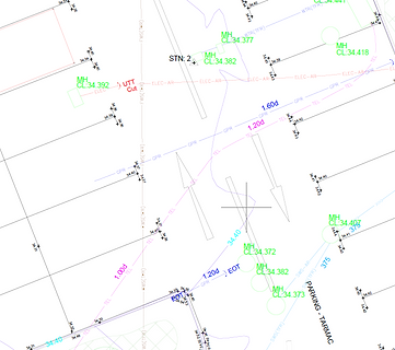
We provide traditional, aerial and mobile mapping topographic surveys, alongside PAS128 compliant utility surveys, combined as required to suit site conditions and project requirements.
Surveys can be delivered as both 2D CAD drawings and 3D datasets, providing an accurate and reliable representation of existing ground conditions, site features and underground services to support planning, design and construction.
Typical deliverables include:
-
2D CAD topographic drawings
-
Terrain and surface models
-
Site levels and feature surveys
-
Buildings, structures and boundaries
-
Hardstanding and surface features
-
Visible utilities and drainage features
-
PAS128 utility survey outputs (including detected and surveyed underground services)


Measured Building Surveys
We provide measured building surveys capturing accurate internal and external geometry of existing structures. Surveys are delivered using an efficient combination of traditional measurement, laser scanning and aerial data capture, selected to minimise time on site while maximising the completeness of the recorded information.
Each survey creates a comprehensive digital record of a building at the time of capture, supporting refurbishment and dilapidation assessments through clear, accessible and verifiable data.
Deliverables include traditional 2D drawings alongside fully integrated 3D datasets. Every project produces a photorealistic digital twin of the building, combining drone and laser scanning data into a registered point cloud, orthomosaic and digital elevation model, together with a tiled 3D model accessible through Soarvo. This enables users to inspect hard to reach areas, tag locations, and extract a permanent photographic record directly from the surveyed environment.
This workflow has been developed through practical project experience, ensuring clients receive datasets that are not only accurate, but intuitive to access and immediately usable.
Typical deliverables include:
-
Floor plans
-
Elevations and sections
-
Internal and external building geometry
-
Registered merged point cloud datasets
-
Orthomosaic and digital elevation models
-
Photorealistic tiled 3D digital twin accessible via Soarvo


Laser Scanning & Reality Capture
We deliver laser scanning surveys using both static laser scanning and mobile mapping technologies, selecting the most appropriate method based on project requirements, accuracy tolerances and site conditions.
Static laser scanning is used where high precision and controlled capture are required, making it well suited to as built verification, engineering environments and complex structures where repeatable measurement accuracy is critical.
Mobile mapping has rapidly evolved in recent years, with advances in hardware and processing enabling high accuracy spatial capture at significantly increased speeds. For many topographic and measured building surveys, SLAM based mobile mapping provides an efficient solution, capturing comprehensive datasets in a fraction of the time while maintaining survey grade reliability.
We specialise in extracting maximum value from merged 3D datasets, integrating static scans, mobile mapping and aerial survey data into unified spatial models that support measurement, modelling and documentation workflows.
Typical deliverables include:
-
Registered point cloud datasets
-
Scan derived information supporting drawings and modelling
-
Integrated 3D datasets forming part of wider survey deliverables


Aerial Survey
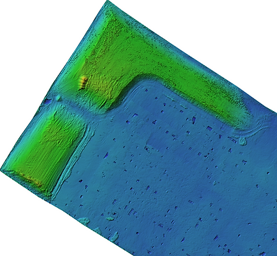
Aerial survey forms a cornerstone of what we do, providing small and large scale data capture using both photogrammetric and LiDAR survey methods, selected according to site requirements, environmental conditions and project objectives.
Aerial survey enables the efficient capture of land, infrastructure and difficult to access environments, allowing the production of aerial topographic mapping across entire sites with a level of coverage and consistency that would be impractical using ground based methods alone. Our approach combines survey grade equipment, robust ground control and carefully planned capture strategies to produce reliable, survey quality datasets.
Photogrammetric survey techniques use high resolution imagery to generate detailed aerial topographic models, orthomosaics and surface data suitable for accurate measurement and analysis. When supported by appropriate capture planning and rigorous processing, photogrammetry delivers exceptionally high detail datasets and remains one of the most effective methods for producing accurate surface mapping.
Aerial LiDAR provides a complementary direct measurement technique, particularly effective where vegetation cover or complex terrain limits optical visibility. By penetrating gaps within vegetation, LiDAR enables the creation of classified point clouds and accurate terrain models, supporting drainage assessment, flood risk analysis, earthworks evaluation and the identification of subtle ground features such as banks, ditches and historic landform features.
Typical deliverables include:
-
Aerial topographic mapping datasets
-
Orthomosaic imagery
-
Digital Surface Models (DSM)
-
Digital Terrain Models (DTM)
-
Site wide topographic information
-
Data supporting drainage assessment and land analysis

Earthworks & Volumetric Analysis
Survey data can be processed to quantify terrain change and material movement across a site, supporting planning, construction and ongoing project monitoring.
By combining ground based and aerial survey datasets, we provide accurate surface measurement and comparison between different project stages, enabling clear understanding of site progression and material quantities. Carefully controlled survey methods ensure that comparisons are consistent, repeatable and suitable for decision making throughout the project lifecycle.
Typical deliverables include:
-
Cut and fill analysis
-
Stockpile and material volume calculations
-
Surface comparison models
-
Terrain analysis datasets
-
Quantity reporting derived from survey data


Aerial Inspection & Monitoring
TWJ Surveys provides repeatable survey and aerial data capture to record site conditions and monitor change over time. Surveys can be undertaken at key project stages to provide an accurate visual and spatial record of progress or existing conditions.
Typical deliverables may include:
-
High resolution inspection imagery
-
Roof and structure capture
-
Progress monitoring datasets
-
Time-based survey comparisons
-
Georeferenced photographic records
Datasets provide a clear, measurable record that can support project documentation, reporting and review.


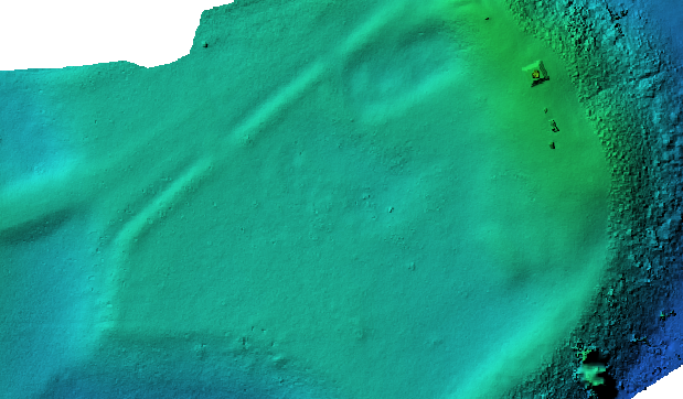
Heritage & Archaeological Mapping
We provide heritage and archaeological mapping services, supporting archaeological units, heritage consultants and conservation bodies through specialist survey and spatial data consultancy.
Our work ranges from the accurate survey of heritage assets and archaeological sites to advising on effective data capture strategies that enable project teams to fully document and understand complex environments. By combining traditional survey, aerial data capture and laser scanning, we produce comprehensive and defensible spatial records suitable for investigation, interpretation and long term archival.
Survey outputs are designed to provide a clear and measurable record of sites and structures at the time of capture, supporting analysis, reporting and heritage documentation requirements.
Typical deliverables include:
-
Heritage asset and archaeological site surveys
-
High resolution terrain and earthwork mapping
-
Survey control and geospatial framework support
-
Registered point cloud and 3D spatial datasets
-
Orthomosaic and aerial mapping outputs
-
Digital records suitable for reporting and archiving
All deliverables are structured to integrate directly with archaeological recording, reporting and conservation workflows.